Helped me discover a tower near my house that I didn’t know existed. Sure you can do your own research but you might miss something, this helped me.
Cellular Tower Survey Reports
About this Item
A stress free way for locating and mapping cellular towers
On the right side here, choose how many towers you want surveyed, the type of report you want, and the approximate height of your home routers cellular antennas.
If you do not know how high up your routers cellular antennas are, or will be, please take a guess.
$60.00 – $204.00
Description
Our Cellular Tower Survey Reports help mitigate the hassles with determining what Cellular Carriers are available at a specific location, their headings, distance, elevation and other pertinent information.
The report can assist in:
- Determining the closest towers to a location for selecting the best cellular tower and carrier
- Selecting an antenna that is compatible with the distance, heights and terrain
- Determining if the height of an antenna mask/tower will obtain Line of Sight with a cellular tower
- Knowing the exact heading to use for aiming a directional antenna
The Reports are offered in two levels of service:
- PDF with Satellite Images
- PDF with Satellite Images and KMZ Google Earth file
Disclaimer: Network carriers are constantly constructing and modifying towers to accommodate new services, frequencies and bands. All efforts are made to ensure the accuracy of our survey reports are based on the most current available data.
Survey Reports are prepared and delivered via email within two business days. Please direct all survey inquiries to: [email protected]
PDF REPORT
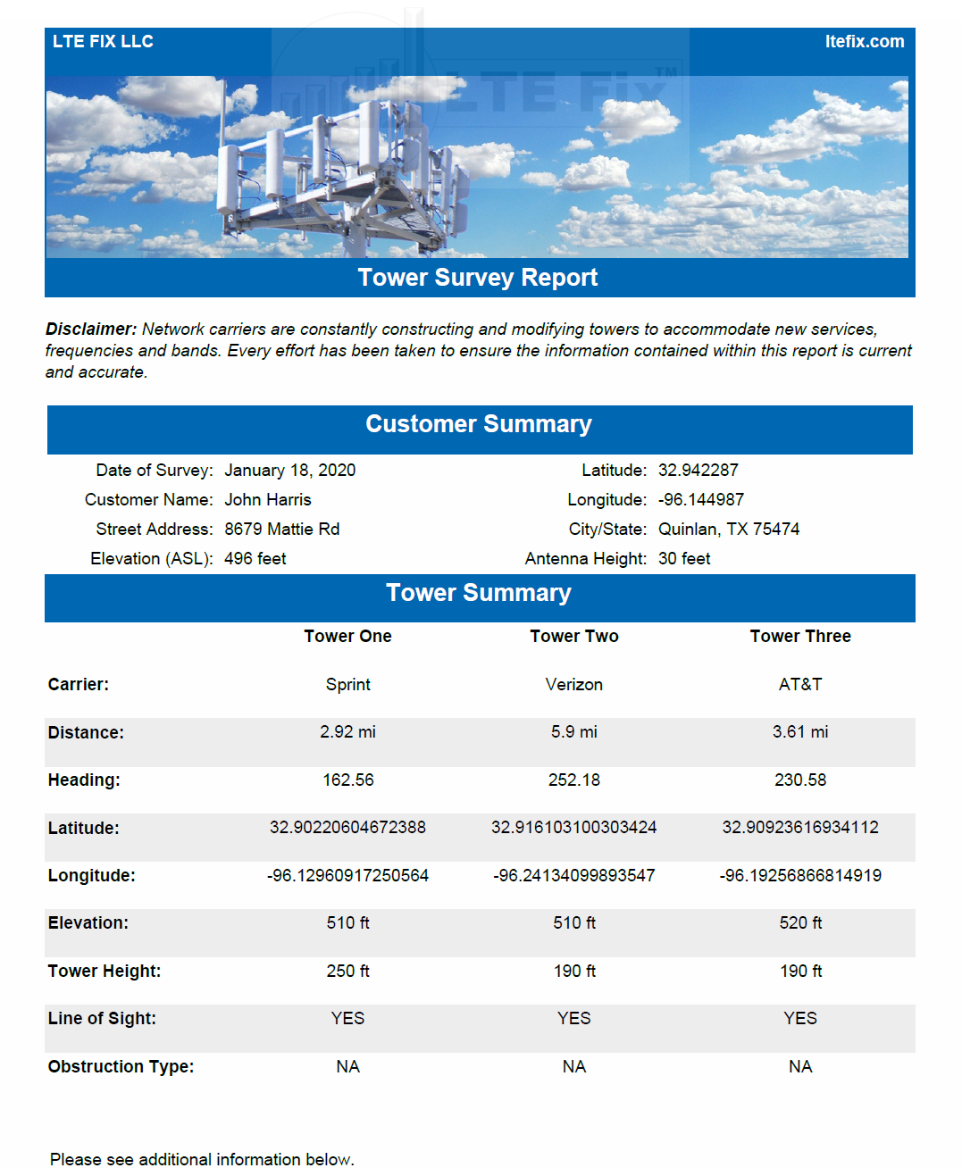
Our PDF format report contains general information on each tower to include:
- Carrier
- Distance in Miles from the users location
- Heading in Degrees from the users location
- Latitude
- Longitude
- Elevation at Sea Level
- Tower Height
- Line of Sight (with the Tower)
- Type of Obstructions (if any)
The information is conveniently compiled on the first page of the report.
EXAMPLE OF THREE TOWER PDF REPORT–SPRINT, AT&T AND VERIZON
PDF REPORT’S SATELLITE IMAGES
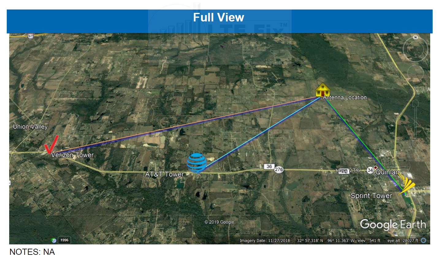
The report also include satellite images for a better visualization of the towers location in reference to a particular location.
The images included is this report are:
- General Overview of all towers contained in a report
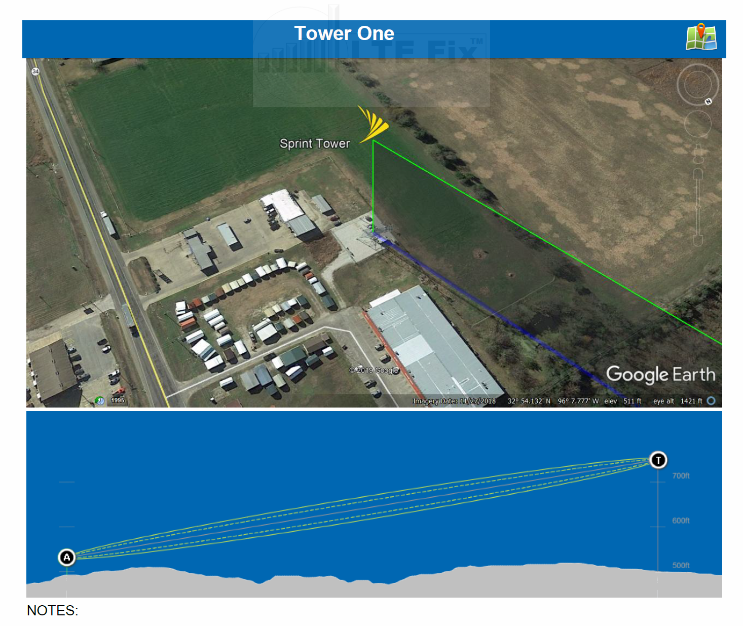
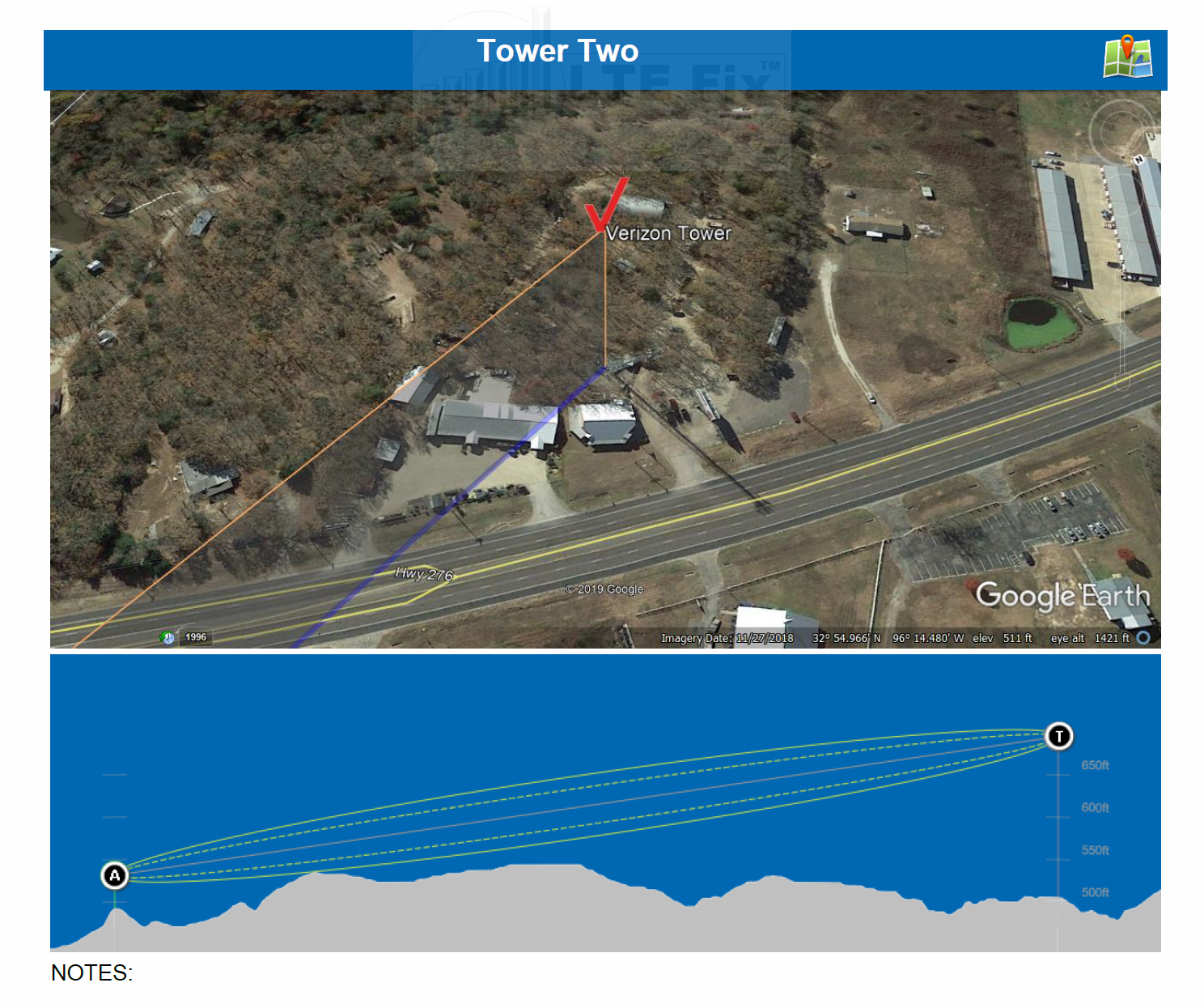
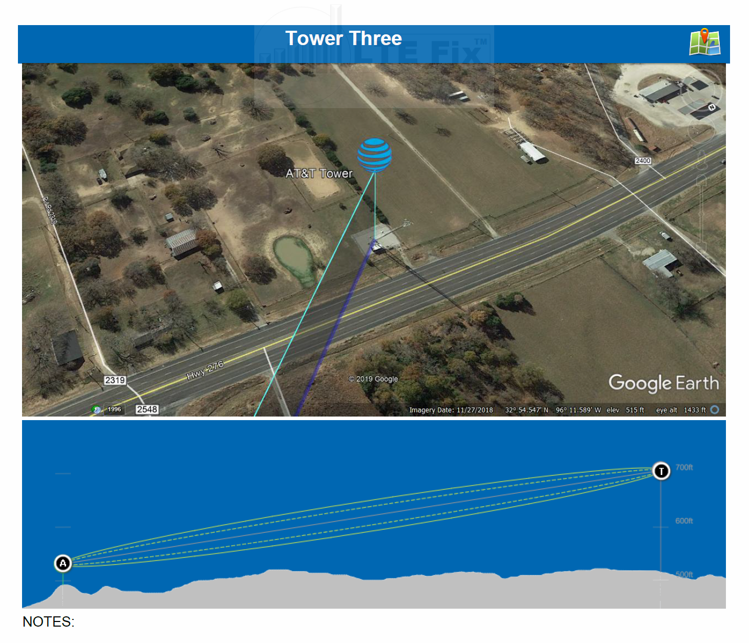
- User’s Location Antenna (“A”) and Cellular Tower (“T”) elevation and topology chart with Fresnel zone for each tower
- Each Tower overview (top right) contains a Google Map icon link that will zoom in on that particular tower
An example of these images based on the PDF three tower survey above are shown below:
GENERAL FULL OVERVIEW
TOWER ONE OVERVIEW AND ELEVATION TOPOLOGY CHART
MAPPING ICON

Clicking on the Mapping Icon on the top right of a Tower will open Google Maps and zoom into the tower’s location (Sprint, in this example).
TOWER TWO OVERVIEW AND ELEVATION TOPOLOGY CHART
TOWER THREE OVERVIEW AND ELEVATION TOPOLOGY CHART
PDF REPORT WITH SATELLITE IMAGES AND KMZ GOOGLE EARTH FILE
This type of report includes the above PDF with satellite images along with a KMZ file for Google Earth. The quick video below will help to understand the value in this type of report.
Additional Information
Line of Sight
When the Survey Report is prepared, the path between the customer’s location and cellular tower is visually examined by the preparer. The path is determined by the height of the customer’s antenna (as provided) and the height of the cellular tower.
The actual location that a carrier’s antenna is installed on a tower–in relation to the overall height of the tower—can impact a path’s elevation over obstacles. This may be further compounded when more than one carrier’s antenna is installed on a single tower.
When a report indicates an obstacle in the path, a brief explanation of the obstacle is provided. Knowing the type of obstacle will better assist in selecting an appropriate antenna system.
Magnetic North
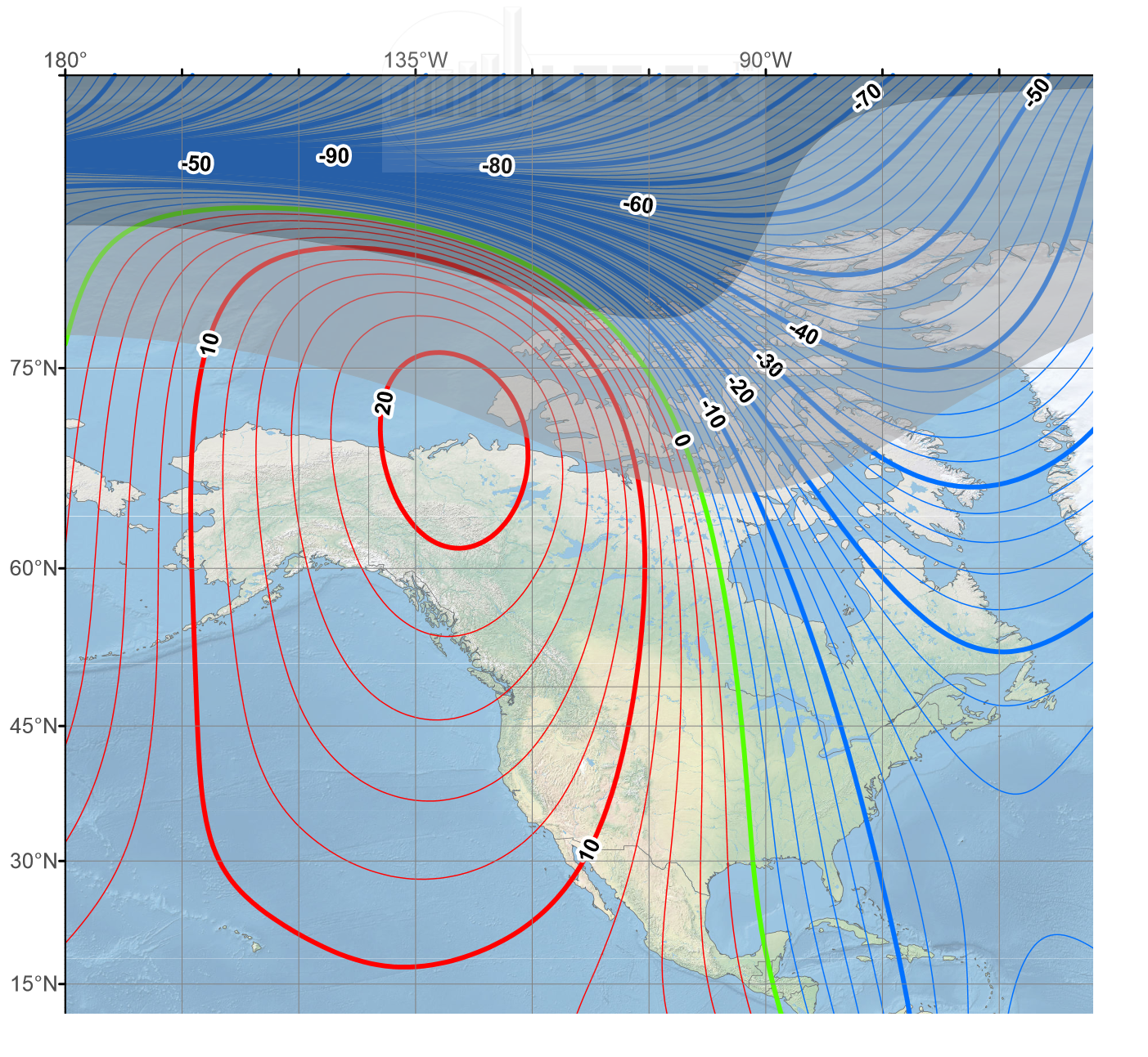
The majority of compasses do not point to the North Pole. They point in the direction of magnetic North, a spot in the Arctic that is near to (but not the same as) the North Pole.
A Survey Report is prepared using Magnetic North headings which may, in certain locations, require factoring in a magnetic variance. This will help assure its accuracy when the headings are used to aim directional antennas.
Read more and obtain your location HERE.
Learn more about True North HERE
Example of Magnetic Declination Chart
Sample Report
FAQ
[vc_row][vc_column][vc_tta_accordion][vc_tta_section title=”I saw a tower closer to me that you didn’t put on my survey. Why?” tab_id=”1630368202352-60edacbd-4907″][vc_column_text]We map towers from your supplied location based on a clear line of sight. There may be closer towers to you without a clear line of sight (blocked by terrain), but we only use those if no other tower is in range.[/vc_column_text][/vc_tta_section][vc_tta_section title=”What cellular bands are on my tower(s)?” tab_id=”1630368202353-08e6c39c-3cb8″][vc_column_text]We do not provide frequency “bands” on each tower. It is nearly impossible to keep up with which bands are active at any given time. Each carrier has a NOC (network operations center) and carrier engineers can change / move / add bands via software at any moment. This is based on usage. If one band is under used, they may move it to a nearby tower.
There are popular resources that you can use try to find this information. CellMapper is a very popular crowd sourced info site for doing this. We do not offer the service to do this for you.[/vc_column_text][/vc_tta_section][vc_tta_section title=”Why are two of my towers shown in the same location?” tab_id=”1630368503362-d3ee676d-36d6″][vc_column_text]Many towers have more than one carrier present. If there is not a tower in range, you may very well get a survey with two or even three carriers on the same tower. We try to find other towers in range but that is sometimes impossible.[/vc_column_text][/vc_tta_section][vc_tta_section title=”What does the “Height of Antennas“ option mean? Why does this matter?” tab_id=”1630368507649-43393913-bbc4″][vc_column_text]The “Height of Antennas” option is the approximate height you will be placing your cellular hotspot/routers antennas. If you are simply placing your hotspot on a shelf, then the height of that shelf, from the ground floor, would be your answer. If you are installing high powered outdoor antennas, then the height that you plan on installing those antennas from the ground level would be your answer.
We attempt to recommend your home antenna heights for best performance. We base this on terrain and the “Fresnel Zone”, which provides the best data transfer performance. We give you a crash course on Fresnel Zones in each PDF survey report.[/vc_column_text][/vc_tta_section][vc_tta_section title=”Does my tower have 5G?” tab_id=”1630368510509-277ee509-8b05″][vc_column_text]”5G” technologies are very new to the open consumer market. Information for which carrier towers are 5G capable is slow to roll out. At this point we cannot provide that information as it is not 100% reliable. As time goes on, it may be easier to determine, but for now we can not provide that.[/vc_column_text][/vc_tta_section][vc_tta_section title=”Where is the Sprint option?” tab_id=”1630368649893-1e2afd84-e2b9″][vc_column_text]Sprint towers are getting much harder to identify, as T-Mobile has begun to aggressively decommissioning and repurposing the Sprint network. Most of the Sprint customers that we have spoken with have verified that they now have access to T-Mobiles bands. If you use a Sprint based service you should gain benefit from the T-Mobile option, but we no longer offer Sprint as an option.[/vc_column_text][/vc_tta_section][/vc_tta_accordion][/vc_column][/vc_row]
8 reviews for Cellular Tower Survey Reports
You must be logged in to post a review.
This site uses Akismet to reduce spam. Learn how your comment data is processed.
- Comment (8)
-
-
I combed through numerous sites, apps, forums, programs and suggestions trying to locate the closest or at least a usable tower for a mobile internet setup. The resulting information was hard to use, incomplete, conflicting and dated. I am also surrounded by heavy woods and hills. Ordered a three tower survey of the closest towers and was overjoyed to discover a Verizon tower less than a mile from my cabin, and an AT&T tower two miles in the opposite direction. Initially thought this has to be a mistake as I have seen no reference to either of these towers. Opened the google earth survey file and WOW, there they were. In hindsight, ordering the survey would have spared me many hours of frustration and work. I highly recommend the KMZ google earth file to explore the terrain, elevation and obstacles on a micro level bases. Exceptional product and service.
-
Great service and communication throughout the survey as they had to work hard to find towers in my rural remote location. Definitely worth the price!
-
submitted my survey request late one night, and received the survey the next morning! the report was very helpful because it located the towers, some of which I knew, but others which I did not. it included required antenna heights, and a useful suggestion on how to repurpose my equipment to use a different (ie: better) tower. when I sent a followup email asking for clarification, I received a quite detailed lucid response the Same day. they included some links to useful information on the ltehacks website. can’t wait to follow their suggestions! I am very happy with the survey – I think it was well worth the price.
-
I’ve been looking into mobile hotspots, modems, etc. for better rural internet access and stumbled upon ltefix/hacks. I decided to give this a try to see how viable all the wireless providers (other than my current) in my area are for this and got exactly what I needed. The survey report gave me a ton of info such as the appropriate height needed for an outdoor antenna for the towers nearby. They even included an extra tower in the survey for free because they noted that one of these towers had multiple carriers. I’m definitely going to be getting hardware from these guys.
-
Wish I did this earlier. Information worth every penny. Spent hours of research and didn’t come up with 5% of the useful information that was in this report. Received the full report within a day and the support team was wonderful to work with. Even through my many questions.
-
I’ve been searching non stop for towers around me, apps and even well known websites were of little help. With the survey I received, it helped locate a tower I didn’t even know was close to me. Worth every cent for sure!
-
At last, some clarity on the location of nearest towers. The Cellmapper app/website is okay but is not exactly user friendly. The Cellular Tower Survey Report gives me granular information about each of the appropriate towers and whether or not they are terrain obstructed. Now, based on trees I can select the appropriate antenna and properly aim the antenna. This level of clarity is well worth the cost.
Leave Your Comment Cancel Reply
You must be logged in to post a comment.
This site uses Akismet to reduce spam. Learn how your comment data is processed.
Related products
-
Netgear Modem and Router Custom Firmware Customer Device Update Service (ORBI 4G and 5G)
Rated 0 out of 5$75.00




MikeyrInJeff (verified owner) –
At last, some clarity on the location of nearest towers. The Cellmapper app/website is okay but is not exactly user friendly. The Cellular Tower Survey Report gives me granular information about each of the appropriate towers and whether or not they are terrain obstructed. Now, based on trees I can select the appropriate antenna and properly aim the antenna. This level of clarity is well worth the cost.
John Hunter (verified owner) –
I’ve been searching non stop for towers around me, apps and even well known websites were of little help. With the survey I received, it helped locate a tower I didn’t even know was close to me. Worth every cent for sure!
RG4Wireless08 (verified owner) –
Wish I did this earlier. Information worth every penny. Spent hours of research and didn’t come up with 5% of the useful information that was in this report. Received the full report within a day and the support team was wonderful to work with. Even through my many questions.
patrick hudson (verified owner) –
I’ve been looking into mobile hotspots, modems, etc. for better rural internet access and stumbled upon ltefix/hacks. I decided to give this a try to see how viable all the wireless providers (other than my current) in my area are for this and got exactly what I needed. The survey report gave me a ton of info such as the appropriate height needed for an outdoor antenna for the towers nearby. They even included an extra tower in the survey for free because they noted that one of these towers had multiple carriers. I’m definitely going to be getting hardware from these guys.
jeff gunter (verified owner) –
submitted my survey request late one night, and received the survey the next morning! the report was very helpful because it located the towers, some of which I knew, but others which I did not. it included required antenna heights, and a useful suggestion on how to repurpose my equipment to use a different (ie: better) tower. when I sent a followup email asking for clarification, I received a quite detailed lucid response the Same day. they included some links to useful information on the ltehacks website. can’t wait to follow their suggestions! I am very happy with the survey – I think it was well worth the price.
Leslie Banduch –
Great service and communication throughout the survey as they had to work hard to find towers in my rural remote location. Definitely worth the price!
EricHickerson –
I combed through numerous sites, apps, forums, programs and suggestions trying to locate the closest or at least a usable tower for a mobile internet setup. The resulting information was hard to use, incomplete, conflicting and dated. I am also surrounded by heavy woods and hills. Ordered a three tower survey of the closest towers and was overjoyed to discover a Verizon tower less than a mile from my cabin, and an AT&T tower two miles in the opposite direction. Initially thought this has to be a mistake as I have seen no reference to either of these towers. Opened the google earth survey file and WOW, there they were. In hindsight, ordering the survey would have spared me many hours of frustration and work. I highly recommend the KMZ google earth file to explore the terrain, elevation and obstacles on a micro level bases. Exceptional product and service.
Joseph Stackhouse –
Helped me discover a tower near my house that I didn’t know existed. Sure you can do your own research but you might miss something, this helped me.